
ExpertGPS v5.41
Shareware
Vista / Win7 / WinXP
Vista / Win7 / WinXP
ExpertGPS is a very advanced GPS map software you can use to plan your trips and outdoor activities.
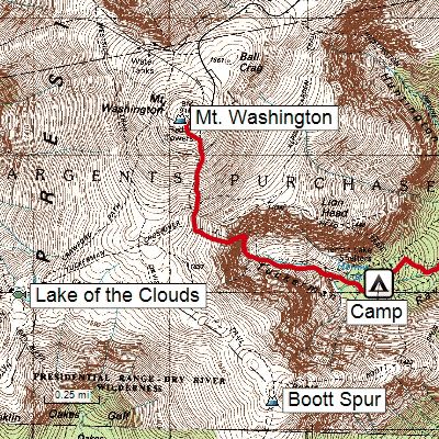
View GPS waypoints and tracklogs from any handheld GPS receiver over aerial photos and US topographic maps.
Plan your next outdoor adventure over scanned USGS topo maps and send a route directly to your GPS receiver to guide you in the field.
It also supports mapping data conversion. You'll be able to convert any GPS, GIS, or CAD data to or from GPX, Google Earth KML or KMZ, Excel CSV or TXT, SHP shapefiles, or AutoCAD DXF drawings in two clicks.
Kuvakaappaukset:
Linkkaa tähän ohjelmaan kopioimalla allaoleva teksti kotisivuillesi:
Lisenssi
Shareware1
Valmistajan kotisivu
Siirry ohjelman kotisivulle
Lisätty
13.6.2015
Latauksia
133
Tiedoston koko
11,65 MB
(< 2min @ 1Mbps)
Tuetut kielet
Englanti
Käyttöjärjestelmä(t)
Vista / Win7 / WinXP1
1Lisenssi- ja käyttöjärjestelmä(t)-kohtien tiedot koskevat ohjelman uusinta versiota.
(Ei arvosteluja)